Tag Archive for: crisis

Photo Credit: iRevolution

The World Bank and Google have announced a collaborative agreement to use a free, web-based mapping tool called Google Map Maker that enables citizens to directly participate in the creation of maps by contributing their local knowledge.

The agreement is aimed at improving disaster preparedness and development efforts in countries around the world. Under the agreement, the World Bank will act as a conduit to make Google Map Maker source data, more widely and easily available to government organizations in the event of major disasters, and also for improved planning, management, and monitoring of public services provision.

The Importance of Local Knowledge

The most innovative component of this agreement, I believe, is the effort to blend scientific and local knowledge to solve local solutions. The need for integrating modern technology and indigenous knowledge into disaster management and prevention has long been overdue. While the technical capability of the new ICTs is huge, it also requires the mobilization of human resources, especially locally available human resources in tackling such disasters.

Just as the expertise of local citizens are being utilized to project their views in urban centers/cities through data-mapping, local knowledge, which is context specific, could be used to interpret the natural landscape of past natural disasters and using these indicators to help in forecasting future disasters. Studies have shown that local knowledge practices are cost effective, and incorporating them into scientific projects could help build local trust of the people. The use of local knowledge such as weather predictions, smells, sounds, cloud color, direction and types of wind, appearance and movements of insects, etc. could be tapped into, in disaster prone communities to help develop sustainable measures in interpreting early warning signals of natural disasters.

Google Map Maker

The Google Map Maker data includes detailed maps of more than 150 countries and regions, and identifies locations like schools, hospitals, roads, settlements and water points that are critical for relief workers to know about in times of crisis. The data will also be useful for planning purposes, as governments and their development partners can use the information to monitor public services, infrastructure and development projects; make them more transparent for NGOs, researchers, and individual citizens; and more effectively identify areas that might be in need of assistance before a disaster strikes.

The World Bank Institute (WBI) and the Global Facility for Disaster Reduction and Recovery (GFDRR) will manage the World Bank’s involvement in the collaboration, building on previous joint mapping efforts. For example in April 2011, members of the Southern Sudanese Diaspora participated in a series of community mapping events organized by World Bank and Google to create comprehensive maps of schools, hospitals and other social infrastructure in this new country via Map Maker technology.

Google has enjoyed a strong relationship with World Bank for many years. As indicated by the World Bank Vice President for the Africa Region Obiageli Ezekwesili, “Today’s technology can empower civil society, including the diaspora, to collaborate and support the development process. This collaboration is about shifting the emphasis from organizations to people, and empowering them to solve their own problems and develop their own solutions using maps.”

Read more on the agreement and possible partnership and collaborations with the World Bank offices.

Photo Credit: NBC Nightly News

The Global development is hosting a live chat with people involved in supporting relief efforts at the Horn of Africa on Tuesday January 10 between 2-3pm GMT (9am EST) to answer your questions on the food crisis and famine at the Horn of Africa.

On the panel will be Clive Jones, chairman of the board of trustees at the Disasters Emergency Committee (DEC), who has been traveling through the region, and Abdalla Rashid, head of Islamic Relief’s Emergency Programs, who works mainly out of Wajir district in north-eastern Kenya.

Some of the general questions to start the discussion are:

  • What is happening on the ground in the countries affected by the crisis?
  • What’s the biggest challenge facing staff day-to-day, or those at a strategic level trying to track and supply a huge area?
  • Why, in a region not unaccustomed to famine, has the food crisis been so bad this time?
  • How can more resilience and better planning be built to prevent this happening again?

The food crisis in east Africa is affecting over 13 million people in parts of Kenya, Ethiopia, Somalia and Sudan. Last year, the UN said the region was experiencing the worst drought in 60 years. On 20th July 2011, famine was officially declared in three regions of Somalia, and on 13th December, the UN made an appeal for $1.5bn to support projects in the country in 2012.

Send your questions now for the online chat and click here to join the chat on Tuesday!

Information and communication is the lifeline of any disaster response. It is critical for people on the ground to convey the situation, as well as the urgent need for supplies and relief in specific locations. It helps organizations collaborate to avoid duplicative effort and gaps in assistance.

The crisis response community has long known that the use of information and communications technology (ICT) can quickly coordinate efforts, thereby making their work more targeted and effective. Recent improvements in ICT, such as availability of BGANs, WiMax and WiFi mesh networks, provide an opportunity to improve information sharing, not only within organizations but also between them.

This blog post illustrates the need for a coordinated collection of baseline data in disaster prone countries through a cross-organizational, multi-phased approach.

The humanitarian sector has the opportunity to harness technological advancements to improve information-sharing during a crisis. Technology is not the solution. But it is a significant tool that can enhance intelligent and immediate decision-making.

The State of Crisis Information Management

Numerous challenges in information management arise when responding to a major disaster or conflict, such as:

  • recording the damage to housing, infrastructure, and services
  • tracking displaced populations
  • distributing the massive influx of humanitarian supplies
  • coordinating the work in and between clusters, as well as the work of dozens of agencies outside the cluster approach

A recent survey of organizations that responded to the devastating earthquake in Haiti pointed out that one of the key issues they faced was an overall lack of baseline information about the situation in the country. For many of the UN clusters operating, it took months to get a comprehensive overview of what the situation was like before the earthquake struck, and then to start understanding what effects it had.

In Haiti the situation was particularly devastating because almost all government offices and ministries had been destroyed in the earthquake, and most of their data systems were lost. This is a common issue faced by response organizations around the world.

Baseline and post-disaster information is collected and controlled by many autonomous parties, including national authorities, many of whom may be working together for the first time. Due to the lack of a common repository of baseline data, organizations spend considerable amount of time either recreating the data or searching for it. Therefore, it is important to improve access to, and interoperability of, data collected before, during, and after an emergency. This is essential to building better response capacity.

Humanitarian response to sudden onset disasters requires:

  • rapid assessment of the spatial distribution of affected people and existing resources
  • good geographical information to plan initial response actions
  • shared knowledge of which organizations are working where (who-what-where or “3W data”) so that response can be coordinated to avoid gaps and overlaps in aid

This applies to any humanitarian response. But in a sudden onset disaster, the timeframes of information supply and demand are severely compressed. Pre-assembled information resources for the affected area may not exist. Even in areas where development projects have been present before the crisis occurred, data is often dispersed and unknown by the wider humanitarian community, or cannot be accessed and assimilated quickly enough.

Recurring data problems include:

  • Discoverable data. Data is either not made available to, or is not discoverable by, relevant organizations.
  • Available data. Data may not be immediately accessible, archived, or stored/backed up in a location outside of the devastated area.
  • Released data. Data sets may be subject to legal restrictions. Even if these restrictions are waived for humanitarian use, there may be problems with immediate authorization and redistribution.
  • Formatted data. Data may be unsuitable for direct import into a database or GIS system, and may require substantial processing.
  • Conflicting data.

Emergencies create an ever increasing number of information web portals, which is in itself a good thing. However, it can be problematic when the data is rapidly evolving. The enthusiasm to (re)publish as much information as possible can lead to confusion and inefficiencies, as users search through multiple copies of similar looking data to extract what is new or different.

The above issues are widely recognized by practitioners in humanitarian information management. Still, these problems recur in almost every sudden onset disaster emergency, in both developed and developing countries.

Each emergency brings together a unique collection of local, national and international humanitarian players. Some are experienced emergency responders, and some are not. Some are government-endorsed, whilst others are simply concerned citizens. While there will be some common elements across every emergency (government, UN agencies, major INGOs), the varying roles played by each makes it impossible to predict a ‘humanitarian blueprint’ for each new emergency. This vast range of experience, resources, and mandates, can make sharing response best practices extremely difficult.

Common problems with baseline data can – and must – be resolved for each emergency. For example:

  • During the initial days of an emergency, the main coordinating agencies agree at a national or local level which administration boundaries and P-code datasets should be used for coordination. It is critical that this decision is communicated to everyone involved in the disaster response.
  • Humanitarian assessment templates and base map data should be standardized and made compatible.
  • The supply of baseline data should be driven by the information needs of the humanitarian response. Priorities differ from emergency to emergency, and this presents a constant challenge in using limited resources to meet urgent information needs at each stage of the response.
  • The information needed by the affected community is not necessarily the same as the information demanded by large humanitarian agencies.

A well-coordinated humanitarian response will use multiple datasets, created by different personnel in different agencies, describing a highly dynamic and multi-faceted situation. To make these datasets interoperable and manageable imposes a higher overhead cost. But to create a data model that is planned strategically versus reactively will minimize that cost.

Moving forward

A multi-agency effort is essential to improve the availability and accessibility to baseline and crisis information. This needs to be a collaborative effort of the entire humanitarian response community with support and involvement of the private and academic sectors. The now no longer existing IASC Task Force on Information Management did a good job by defining what the Core and Fundamental Operational Datasets (COD/FOD) are that we need to collect for each country, but the difficult part is to actually ensure they are available for each country and that those that have been collected are actually kept up to date.

We at NetHope are looking at new and innovative ways to address this and are looking for organizations who are interested in working with us on this. If you want to work with us on this, feel free to reach out to me for further information.

Malnourish child in hospital Photo Credit: Abdi Warsameh, AP

Photo Credit: Abdi Warsameh, AP

Farhiya Abdulkadir, 5, from southern Somalia, suffers from malnutrition and lies on a bed at Banadir hospital in Mogadishu, Somalia. Her growth is stunted, her belly engorged, and the muscular tissues keeping her organs functioning are slowly wearing away—the five-year-old is deteriorating to death.

Farhiya is dying from famine, starvation, and malnutrition; but a packet of the peanut buttery Plumpy’nut could help bring her back to life.

The U.N. declared a famine late last month in parts of southern Somalia where tens of thousands of people, mostly children, have died, in what aid officials call the worst humanitarian crisis in the troubled country in over two decades.

Despite dire conditions, where one-third of the population of Somalia is facing starvation, militant Islamist group al-Shabaab has been deflecting international aid where help is needed the most.

A couple weeks ago, Edward Carr who works in famine response for USAID on the ground in the Horn of Africa, observed that despite similar drought conditions in Kenya and Ethiopia, the state of Southern Somalia is critical, “we cannot get into these areas with our aid…famine stops at the Somali border”.

How does he know, then, exactly where aid is needed, how much is needed, and will be needed in the upcoming months?

The USAID-supported Famine Early Warning Systems Network (FEWS NET) is a system helps to identify timely information on the most affected areas, urging the global humanitarian community to move quickly and scale up their relief efforts on evolving food security issues.

FEWS NET summarizes the causes for the famine as:

The total failure of the October-December Deyr rains (secondary season) and the poor performance of the April-June Gu rains (primary season) have resulted in crop failure, reduced labor demand, poor livestock body conditions, and excess animal mortality.

FEWS NET estimates that a total of 3.2 million people require immediate, lifesaving humanitarian assistance, including 2.8 million people in southern Somalia—highlighted areas are the Bakool agropastoral livelihood zones, and all areas of Lower Shabelle.

So what is the next step?

FEWS NET identifies these issues, and using a group of communications and decision support tools, recommending decision makers to act quickly in order to mitigate food insecurity in Southern Somalia. These tools include briefings and support for contingency and response planning efforts.

Currently, FEWS NET has helped organizations, such as the U.N. Food and Agriculture Organization’s (FAO), the Red Cross, and U.N. groups, such as the World Food Program (WFP), who are on the ground delivering aid, obtain timely information on what is needed and where.

Last Wednesday, WFP deployed a plane from Kenya with 10 tons of food—one of the many airlifts of the nutritional packets that will take place in the upcoming months.

The FEWS NET Food Security Outlook in the Horn of Africa for August-September 2011 predicts that in these upcoming months, the famine will inevitably spread and last until at least December.

Hopefully, the FEWS NET is the type of system that will help automate an humanitarian response from the international community—helping internally displaced children like Farhiya suffering from malnutrition, eat something before their condition deteriorates.


I recently had the great opportunity to visit Japan for the second time since the devastating earthquake and tsunami that struck on March 11th this year. My first visit was roughly 2 weeks after the disaster and at that time I spent most of my time in Tokyo coordinating ICT support to the NetHope members active in Japan. During my first visit, things were starting to get back into normal in the capital Tokyo, although almost constant aftershocks brought people back to the reality of what had occurred just a few weeks earlier. It was however great to see the tireless efforts of the various non-profit organizations to provide support to those affected. Even in a well prepared country like Japan, there are simply not sufficient government resources and expertise to deal with something of this magnitude.
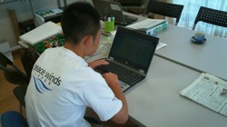
PWJ Staff using donated laptop
During this visit we handed out a total of 250 laptops to NetHope members and their local implementation partners. NetHope received these laptops as generous in-kind donations from Dell and HP and they were all configured ready to use, thanks to another generous donation, this of one of software from Microsoft Corporation. Getting them shipped over to Japan was also made possible by yet another generous donation, this one of shipping services from DHL.
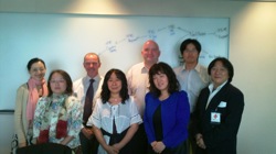
Local Chapter Meeting
This time I spent half my time in Tokyo and the other half visiting the affected areas in Miyagi and Iwake prefectures. While in Tokyo I followed up on projects we started back in March and also had the great opportunity to attend the inaugural meeting of the NetHope Japan Chapter. This was the 12th local chapter we have established within NetHope. Local NetHope chapters play a very important role when disasters strike, because they enable coordination at the local level between the NetHope member organizations. It has often been said that having established relationships with other humanitarian organization is the key to successful coordination and we have seen this a number of times in countries that have local NetHope chapters when disaster strikes. Just knowing who your colleagues are allows for spontaneous coordination and collaboration to happen. During the inaugural meeting we also had representatives from our partners Cisco and Microsoft Japan (who graciously hosted the meeting). This is important as well, since it builds partnerships between the local NetHope members and the local offices of NetHope partners.

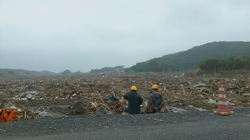
Fields of debris in Iwake

During my first visit, the phase of the disaster changed from the immediate rescue phase to the relief phase. Focus shifted from searching for survivors in the rubble to providing relief services to those that had survived. Most people had moved into evacuation centers and the main focus was to ensure they were receiving food, shelter and other basic services. It was therefore interesting that during my second visit there was also a change in phase. Focus was shifting from the relief services to recovery or reconstruction. Temporary housing has already been set up for a large portion of those affected and the plan is to move everyone out of evacuation centers by the end of the summer.

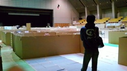
Sleeping area in evacuation center
Although life in the evacuation center is no luxury, people sharing auditoriums and gyms with hundreds of other people, it also provided a safety net of some sorts for many people. While staying in the evacuation centers they got food, clothing and had access to other basic services, all for free. Moving into the temporary housing, although free, requires people to pay for electricity, food, telephone and other basic needs. This means that they have to find jobs to be able to afford these basic necessities. Many of those affected used to work in the fishing industry and due to the destructive force of the tsunami the boats, factories and harbors along the coast were all destroyed. A number of NetHope member organizations are working with local authorities in the affected communities on creating new livelihood opportunities for these people.
One of the great things about this trip was that I got Paul Chiswell, who is a director at our great partner and supporter Cisco to join me for the trip. Paul and I sit together on a sub-committee of the US State Department that focuses on ICT support during international disasters. During the initial weeks of the Japan earthquake/tsunami response, having relationships with people in the US State Department had helped us at NetHope tremendously in getting ICT equipment shipped over to Japan without it getting blocked in customs for days or weeks like so often happens. The US State Department and the FCC got us in touch with their counterparts within the Japanese government and as a result we were able to pre-warn the customs authorities that this equipment was coming and that since it was being used for relief services then it would not get stopped by customs. For him it was a great opportunity to see not only how generous support, both financial and in-kind in the form of networking equipment from Cisco had helped, but also to see how some of the work we had done in the sub-committee was already being put in practice.

Me and Paul visited the affected areas in Sendai and Shichigahama in Miyagi and Ofunato, Rikuzentakata and Kesennuma in Iwake prefectures. No words can describe the amount of destruction we witnessed. Close to 400km of coastline had pretty much been wiped out. Everything below 10-20m of altitude along the coast had been either seriously damaged or completely destroyed. What was however surprising was to see how houses built above the line of destruction had actually suffered less damage than I had expected. Reason for this was the fact that building codes in Japan are very strict and houses are built to withstand earthquakes. This is reflected in the fact that estimates are that only a few hundred people at most died in the earthquake itself. It was mainly the tsunami that followed that resulted in the massive loss of life.
Paul playing with a kid in a child friendly space
We had the opportunity to visit one of the evacuation centers to see how Plan Japan (local branch of NetHope member Plan International). In this evacuation center, Plan International has set up a child friendly space where the kids can come and play or do their homework. For those that have not been in an evacuation center it may be difficult to understand the concept of a child friendly space. But when you see how people live very close to each other, separated only by cardboard boxes you realize that the kids get very little possibility to play or talk to each other. The child friendly spaces are therefore a crucial place they can release some of that energy and also talk about some of the experiences they lived through. Plan has been working closely with teachers and psychosocial services in the affected areas, providing them with guidance on how to help the kids out dealing with the psychological effects of the disaster. It was very educational to visit the evacuation center, see how well organized they are and to better understand the conditions that people live in.
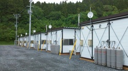
Temporary housing complex in Ofunato
The day after we went to visit PeaceWinds Japan (PWJ) a local implementation partner of NetHope member MercyCorps. PWJ is working up in Iwate prefecture and we began by visiting their local office in Ichinoseki. The reason they set up the office in Ichinoseki is that even though there was some minor damage from the earthquake, most basic services such as electricity and telecommunications were available within days of the quake. The staff then drives on a daily basis down to the various smaller cities and villages along the coast where they were doing their job. We visited a new temporary housing facility that has been built in Ofunato. The temporary housing facility was built on a baseball field. The temporary “houses” are built together 6 in a row, similar to trailers, but they certainly would have given the famous FEMA trailers for Katrina a very bad name. All together there were 12 groups of houses like this, so in total there were 72 apartments. Every apartment had a small living room/kitchen and a sleeping room. They were also had electricity, TV and telephone installed in each apartment. We did notice that no internet connectivity was provided. We are however working on a project with Cisco Japan and Toshiba Japan to provide internet connectivity to some of these temporary housing facilities as well as tablet computers.
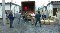
Volunteers bringing supplies into the temporary housing
The temporary housing is provided with basic appliances such as fridge, washing machine and TV, but it is through support of non-profit organizations like PWJ to provide all the other things needed, such as plates, glasses, cleaning equipment, etc. When space permits there is also a community building next to the groups of houses, allowing for various social support services to be provided. These temporary houses are what many people will be calling their homes for the next two years. At that time, people are expected to move out of the houses into their own permanent housing.
The work in Japan is far from over. The debris and rubble is starting to be removed and people are moving into the temporary housing, but the psychological effects and the recovery efforts will take years. It is especially during this period that it is important to continue supporting the work of the great non-profit organizations that are doing an amazing thing supporting these people who lost everything. The spotlight of the media may be gone, but thankfully the spotlight of the non-profits continues to bring light to the life of the people affected. It is through the use of technology like NetHope partners provided as in-kind support that this work can be made more efficient and easier. At the same time we must also continue to improve preparedness for future emergencies. Scientists believe that the massive earthquake of March 11th has increased the likelihood of an quake in the Tokyo fault line which has the threat of affecting even a bigger population.

When a large scale disaster strikes the world watches. Twitter gets flooded with reports, pictures and prayers. CNN, BBC, Sky News and Al Jazzera all break their regular programs to show us terrifying images of what is happening.

Thankfully only 2-3 large scale disasters strike every year. Depending on the magnitude and location of the disaster, the media and people loose interest within a few days or weeks. At the same time we have many medium scale disasters that happen around the world on almost a daily basis. If they strike US then we hear about them for a while, but if they happen in remote places of the world like Sri Lanka, Indonesia or Ghana then they at usually go un-noticed by most people. This is however usually not the case for the local media and the local population of the country affected.

In the last 2 years we have seen efforts being born around utilizing social media, social networks and digital volunteer groups to help deal with the explosion of information that we now get through mobile phones and social media. While these efforts are promising and do provide us with opportunities for gathering, processing, analyzing and disseminating information in ways we have not been able to do so far, then they do fall short in one important part and that is that they are not sustainable for the long-term and repeatable for the large number of disasters that occur every year.In my visits to disaster prone countries, where I have been speaking to them about the importance of preparedness, they all spoke of interest in all of these new technologies and efforts that have been getting so much attention in the press and at conferences around the world.

What they complain about is that nobody has reached out directly to them and shown them how they can make use of these tools. The reason is that we in the global humanitarian and technology community have been too focused on trying to figure out how to do things at a global scale that we have largely ignored the local perspective. Some might argue that the jet-setting trips of the leaders of the digital volunteer community to conferences around the world have been focusing on this effort, but I would like to argue that in most cases these have not necessarily resulted in more than short-term awareness building. Often these conferences have also been mainly attended by people who are not active in the disaster response community.One could also say that recent efforts of setting up crowd-maps following disasters in Pakistan, New Zealand and Japan, driven by local actors are samples of how things really work.

While I agree that great work has been done by those local actors, then I would also argue that much greater work could have been achieved if we had focused more on preparedness and building local capacity before these disasters struck. Then we could have ensured that the information gathered was actionable and relevant to the response. We could also have ensured that the response community was utilizing this new medium to the fullest.Over the last year we have put a lot of focus into building a global capacity to deal with crisis. We have established the Stand-by Volunteer Task Force, we have established connections with the global response community (UN, NGOs, Red Cross) and we have had great examples of how this effort can really provide information to the response community.A promising change to this was an effort lead by the US State Department that started last week in Indonesia under the name TechCamp Jakarta. There they brought together key people from the new technology community and some of the actors from the local response community. It was a great first step, but more is needed to follow up on this.

What we need to do is to put focus on building up local capacity in disaster prone countries, especially those in the developing world. We can then leverage the global capacity we have already built up to help support these local efforts when their capacity is overwhelmed. We can also leverage the technologies, processes and training we have already put together for these global efforts. So what is needed to build up that local capacity?

1) We need to bring together the various actors involved in disaster response in the country. This includes the government, the UN, the NGOs, etc. Often there may be existing forums that can be leveraged, but often these need to be extended to ensure inclusiveness of all the local actors.

2) We also need to bring in the local technology community. They are the ones who can help adapting the global solutions to the local needs. This includes members of the local open-source community, but also people from the private sector technology companies.

3) We also need to bring in the academic community. Students have in the past been the basis for any grass-root effort we have seen around crisis information management. Together these various actors from the different communities make up the local crisis information community.

4) We need to provide standardized & localized, on-line and in-person training to this community on how to utilize these technologies to achieve better information sharing during disasters.

5) We need to drive awareness of the potential of these efforts to the response community. Through that awareness building we can build the relationships needed between the volunteer community and the response community

6) We need to provide standardized yet flexible processes that the local community can utilize to ensure that their efforts are actually resulting in providing actionable and accurate information to the response community.

7) We need to work with the local mobile providers to establish short-codes for citizens to use for direct reporting into the systems.

8) We need to provide the local community with awareness building material (advertisements, banners, etc.) to build a volunteer community and to make citizens aware of short-codes.

9) We need to provide the local community with mentorship from the global community on establishing the community and running this effort.

10) We need to work with local web portals (newspaper, social networks, etc.) to get them to direct people towards the efforts of the local community instead of establishing their own.

11) We need to help the local community run simulation exercises where they can train their volunteers and first responders in utilizing the technologies.

12) We need funding from the donor community to help drive these efforts in 20 of the top disaster prone countries in the world.

In my discussions with the response community in Indonesia, then the recent TechCamp event generated an interest that we should leverage to pilot a local capacity building effort for one of the most disaster prone countries in the world. I know the interest within the response community is high and that the BNPB (Indonesia’s version of FEMA) would welcome better information sharing amongst the various responders. Big question is if we can leverage that interest to find donors who are willing to fund a crisis information management “revolution” one disaster prone country at a time.

In my trip to Pakistan earlier this year, I learned first hand about the power of preparedness at the community level. I visited a small “displaced” village on the banks of the Indus River. I asked them if there had been any early warning system in place for the floods. What they told me was that they had listened to radios to hear news about the flooding as it made its way down south. They had also received phone calls from relatives and friends up north telling them about the scale of the flooding.

But what really caught my interest was the fact that earlier in the year, one of the local NGOs that worked as an implementation for our NetHope member had visited this village to provide disaster risk reduction training to the people. They had explained the basics of disaster preparedness by showing a video on a laptop computer.

The local NGO then told me that they could see a dramatic difference between the villages that had received the training versus the ones that had not. In the ones that had received the training, people had brought their valuables to higher ground before the flood waters started rising. They had also in some cases harvested their crops before they were ruined by the floods.

Just providing this short and simple awareness building at the local level can really make a difference in how people prepare for the floods. And technology can help in this as the story shows. It is much more effective to be able to show a video than to bring leaflets or simply speak to people. Having the ability to bring something like a laptop with a pre-loaded video allows for even remote villages to be visited.

Of course we can say that the early warning system was very limited in Pakistan, but as always people find ways if they are aware of the danger. They reach out to their friends and relatives living up-stream to form their own little advisory network.

Way too many early warning systems are based on the pre-tense that there needs to be large investment by the government and that the government needs to warn everyone.

But as social networks such as Twitter and FaceBook are showing us then it is about the community of people you know and the community you live in. We must find simple and cost-effective ways of helping people connect to those around them through the technologies they have and thereby amplify these people-based networks of early warning.

This week I will be attending the Global Platform for Disaster Risk Reduction and I look forward to meeting people from around the world and from organizations working on preparedness activities. For updates from the conference follow the Twitter tag #gpdrr2011

Six weeks ago the devastating force of mother nature reminded us again how things can change in a matter of a few minutes. For the first time we were able to watch live images of the destructive power of tsunamis as they struck the coast of Japan following a massive 9.0 earthquake. I have spent most of my time since March 11th, working on supporting the NetHope member organizations active in Japan.

It now appears that over 27,000 people died as a result of the earthquake and the tsunami that followed. Over 500,000 people were affected and close to 70,000 families lost their homes. Many towns and villages along the coast were totally wiped out.

But instead of focusing in this blog post on the aftermath of the disaster then I rather want to focus on what didn’t happen because of how Japan has invested in disaster risk reduction activities or what is often called emergency preparedness.

It is my firm believe that if this disaster had struck any other country than Japan then we would have seen the number of deaths multiply by a factor of 5-10. Ever since the big Kobe earthquake in 1995, the Japanese have spent lot of effort on disaster risk reduction activities. This includes systems for monitoring earthquakes and tsunamis. This includes systems for warning about impeding earthquakes and tsunamis. It includes running training and awareness programs for citizens.

Japan has a very extensive network of earthquake detectors. These monitor both the S and P waves (see this Wikipedia article for a great overview of how the difference between those two waves can be used in early warning). When a strong earthquake is detected through these monitors then a public warning is issued. I got to experience this first hand when visiting Japan at the start of April when a series of 6.5-7.1 aftershocks struck within a 48 hour period. In one case I was in a meeting on the 31st floor of a building an through the loudspeakers we were told a strong earthquake had been detected and would arrive in 10-15 seconds. About 7 seconds later we could feel the tremor. This of course works best when the earthquake strikes at a bit of distance, but there are also examples, at least from Taiwan that I know of where this is used to automatically slow down high speed trains and open up elevator doors.

But more importantly on March 11th was the early warning and training on the potential of tsunamis. Japan being a country that “frequently” gets struck by tsunamis has developed a very good system of monitoring ocean movements, but also of warning people. Regular evacuation drills are done in coastal areas and people are educated on the dangers of tsunamis. It was especially this effort that saved tens if not hundreds of thousands of lives on March 11th.

It has often been said that a dollar spent on preparedness saves at least six dollars in response costs. With the March 11th earthquake being the most costly disaster ever worldwide, with at last $300 billions in material damage according to government estimates, that figure might easily have risen substantially and caused even greater effects on the overall world economy.

It is therefore important for donors and governments around the world to learn a lesson from the people of Japan. Even though it might sometime be difficult to justify spending money on preparedness it is at times like these that we are reminded of its value. Lets make strategic decisions to move in that direction before the images of the devastation in Japan are too easily forgotten.

On May 10th-13th, 2500 representatives of national governments, regional and international organizations, civil society and non-profit organizations come together for the Global Platform for Disaster Risk Reduction. It is my challenge to those showing up there, including myself, that we put our money and action where our mouth is and not just talk about preparedness but actually start working full-force on preparedness activities that will pay off multiple times when the next disasters strike.

I recently finished a chapter for a book to be published by the National Defense University about the persistent problem of information asymmetry in disasters, the condition by which information is disaggregated in such a way that it compounds the already horrendous logistics struggle of humanitarian organizations to provide life-saving aid to victims. Food drops are missed by the general population, the wrong supplies get to the wrong hospital, and water sits on a tarmac rather than getting into the hands of people who are desperate for it. Information asymmetry has two dimensions: the inability to get any data from a lack of access to that information or the inability to take aggregated data and make sense of it all. Often in disasters the first dimension is attributed to a lack of connectivity – whether because of geography or lack of infrastructure (cell phone towers tend to collapse in earthquakes, floods etc.). Six years ago, NetHope and a variety of private sector partners tackled the condition of connectivity in disasters with the creation of the Network Relief Kit (NRK) . The NRK, which fits in a backpack, has a BGAN satellite receiver about the size of a medium-sized textbook. It provides a broadband connection to the Internet, runs off a car battery (or small solar panel) and works almost anywhere on the planet. It has a built-in wireless router for WiFi to support up to ten laptops or Internet phones. So it creates a fast, temporary but crucial voice and data communications hub for a small group of fieldworkers when they need it most immediately – in emergencies.
While the NRK does amazing job of connecting, there are some disasters where the lack of connectivity is compounded in places (like Myanmar after Cyclone Nargis or today’s current conflict in Libya) where autocratic regimes have “shut down” the telecommunications infrastructure or restricted access to journalists. It becomes a situation of not just being able to get public information out but a condition of not being able to get any information at all. As we have seen over the last few weeks, when networks or communication is shut down people revert old network connections (mesh or dial-up) in order to harness new platforms– Twitter, Facebook and other social media – to subvert these network shutdowns. It’s outstanding ingenuity – voice to Tweet for example – and innovation that is providing us with a slew of crisis data. So now we have the information but what do we do with the data? This is the second dimension of information symmetry.

This weekend I met with Gisli Olafsson, NetHope’s Emergency Response and Preparedness Director, as we were both speaking at Harvard for separate events (who knew Harvard was the hotbed of technology, connectivity and enterprise). Gisli, whose blog on disaster response is a great read for anyone interested in this space, told me about the efforts of NetHope, OCHA, and countless other organization and volunteers around the world. Spread across the globe, connected by technology and social media this group is monitoring social media, mainstream media and response organization reports for updates on the terrible situation in and around Libya. I remember this group well from my time in Haiti almost a year ago. Following the devastating earthquake in Haiti this volunteer community rose up to try to help in their own way the people affected by that terrible disaster. Thus was born a new opportunity to improve situation information management that leveraged the human capital of countless volunteers around the world to tackle the very sticky problem of information asymmetry.

Screenshot of Libya Crisis MapThe efforts of this group (OCHA, UNOSAT and NetHope have been collaborating with the Volunteer Technical Community (VTC) specifically CrisisMappers, Crisis Commons, Open Street Map, and the Google Crisis Response Team over the past week) are available now for the public here. For the general public this is a fascinating look at the revolution of connectivity, technology, social media in reporting and responding to one of today’s most pressing global crisis’. For the people of the UN and its agencies, NetHope’s 32 international NGOs and countless others who are responding to the crisis this information provides the pivot point for rapid response and an important tool in overcoming the persistent condition of information symmetry. As this movement gains stream and structure the chapter I wrote less than six months ago may become a bookmark of the past as we begin to stage our response and resources in a way that saves countless lives – but hey I’m not going to feel too bad about my outdated chapter because that is the pace of innovation coupled with the persistence of the human spirit.

Copyright © 2020 Integra Government Services International LLC