Tag Archive for: water

The four categories of ecosystem services, and examples of those services, as defined by the Millennium Ecosystem Assessment, 2005.

Ecosystem Services: Categories and Examples

According to the Millennium Ecosystem Assessment, ecosystem services are defined as the benefits people obtain from ecosystems, split into four categories of provisioning, supporting, regulating and cultural services. Because they are so beneficial in a variety of ways, the international community has begun to monitor and monetize these services, in addition to advocating for environmental sustainability.

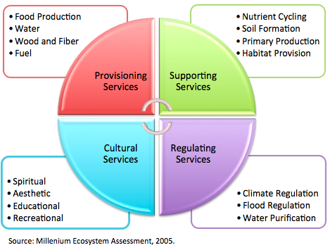
Each category of ecosystem services provides a certain type of benefit to the global population.

  • Provisioning services are often described as ecosystem goods, and refer to benefits such as food production.
  • Supporting services are services that enable other categories to work, including but not limited to nutrient production and habitat provision.
  • Regulatory services, such as carbon storing, are processes often considered to be public goods, and are perhaps the most difficult to measure.
  • Lastly; cultural services refer to social aspects of the ecosystem, such as the services sacred land provides and eco-tourism.

As climate change increasingly warrants international attention, a system that measures and monitors the benefits of ecosystem services will prove to be more necessary than ever before. In addition to having a set measurable indicators, it will also be valuable to monetize these services for both the public and private sector.  Fortunately, some of the information and technology needed to perform these functions are already in development. The US Department of Agriculture for example, recently launched Comet 2.0, a web-based tool to help farmers estimate farm-specific carbon sequestrations and net greenhouse gas emissions from soils, biomass, annual crops, and fossil fuel usage.  Another tool, the i-Tree, allows municipalities to monetize the value of urban trees, and is used in over 6,000 communities worldwide for city planning initiatives.

Recognizing the monetary value of ecosystem services, the private sector has also begun to show their commitment to the environment as part of an overall business strategy. This past June at the Rio+20 Summit, 24 global Fortune 500 companies including Coca-Cola, Dell, General Motors and Xerox, released a report called The New Business Imperative: Valuing Natural Capital. The report, sponsored by the Corporate Eco Forum and The Nature Conservancy, urges businesses to recognize how their companies are dependent on ecosystem services in a range of areas, from supply chain to cost savings.  Complete with a commitment from each company involved, the report estimated the world’s ecosystem contributes about $72 trillion in goods and services per year to the global economy.

While ecosystem services may be a relatively new topic on the environmental agenda, the momentum behind the discussion is building. In fact in February 2012, the UN Statistical Commission recently approved the System for Environmental-Economic Accounts (SEEA) to account for material natural resources in a nation’s economy. It should be noted however, that an internationally accepted method of accounting for ecosystem services, as opposed to goods and materials, does not currently exist.

Because this is an increasingly important topic with a potential impact on Environmental Natural Resource Management (ENRM), we’ll be taking an in-depth look at ecosystem services in the areas of disaster risk reduction, food security, health and technology. Each week, we’ll look at specific areas of ecosystem services and how they fit into the larger development picture.


Rural villages around the world lack reliable access to water and technology. Like a broken record, a common mistake made my aid groups that go into such communities is the failure to properly teach local groups how to properly care for, use, and integrate complex, expensive equipment. It breaks and becomes a physical reminder of broken promises.

Kayarani, a small village in Bolivia made up of subsistence farmers is one such example of a locality where past campaigns to improve sanitation has produced mixed results. The NGO Water for People is attempting to avoid previous mistakes by working with local community and government officials for effective engagement in building a sustainable water system and latrines.

A critical aspect of Water for People’s approach in remote villages like Kayarani is its Android feature that uses GPS and GoogleEarth software. The feature program is called FLOW (Field Level Operations Watch). FLOW offers an easy way to collect data, aggregate photos, conduct surveys, and communicate information via mobile phone within the area. FLOW was built by Water for People in 2010 to provide accountability and transparency to donors and the public.

FLOW is different from other programs in that it’s much easier to maintain accountability through its instant feedback electronic database. This accountability allows Water for People and the local community to find creative, collaborative solutions using data that challenge anecdotal norms. FLOW is adaptable, allowing users to create surveys on any topic in order to best reflect the impact of the project. The fact that it’s a phone feature means that data can be collected anywhere and later automatically uploaded if there isn’t a mobile connection.

In 2011, Kayarani built a gravity-fed water system with assistance from Water for People and the local government. This system provides reliable and safe water for the fifty families in the community. The infrastructure was co-financed by the local community to encourage maintenance. The local government also provides hygiene education through a worker who regularly visits every household to collect data throughout the different phases of the water and sanitation project. A FLOW worker will continue to monitor and evaluate the project for ten years, ensuring that everyone in the village has adequate access to water and sanitation forever.

SciDev.Net reports the success of  a mobile phone application that can be used by low-cost feature phones to monitor local water quality via SMS. The Water Quality Reporter (WQR) can be used to check microbiological contamination, and carry out residual chlorine and hydrogen sulphide tests. 

The application was developed using open source programming and iCOMMS software, iCOMMS is part of the University of Cape Town. This team has also developed mechanisms for integrating water quality results into existing information systems.

iCOMMS wishes to expand the application, which is available for download at their site,  into the greater network of water treatment processes.

Integration of environmental data is critical for water. WISDOM, a Vietnamese-German project, is an inspirational model of how watershed management leads to sustainable use and preservation of water resources. WISDOM combines information from hydrology, sociology, information technology, and earth observation for its implementation of an Information System for the Mekong Delta.

The Mekong Delta struggles against population increase, changing climatic conditions, and regulatory measures. Because of these challenges, extreme flood events occur more frequently, drinking water availability is increasingly limited, soils show signs of salinization or acidification and species and complete habitats are diminishing.

WISDOM’s integrated information system contains available and newly generated data from multiple disciplines, open to users through an accessible query. The IS allows a feed of input from remote sensing, GIS, digital maps, in-situ, interpolated point measurements, and other sources. Available data includes flood and drought risk, water quality, sediment load, discharge, and land use changes.

Lessons learned from this initiative include that the cooperation of national institutes and regional or local authorities needs to be strengthened. Successes include the knowledge transfer provided between German institutions and Vietnamese doctorate candidates and the user-friendliness of the IS that can answer specific and complex questions that support regional planning activities.


WaterWiki.net, a UNDP, UN-Water initiative recently relaunched and added more features such as a LinkedIn discussion forum. WaterWiki is a useful resource and popular forum for practitioners and agencies. It features over 800 articles, case studies and reports.

Some of the best features:

Telecom operator Orange Kenya has asked the government for a KES 10 billion ($120 million) bailout, news reports revealed on Wednesday. The move comes as the company continues to incur massive debts following its 2007 buyout by France Telecom.

Orange Kenya CEO Mickael Ghossein.

Orange Kenya CEO Mickael Ghossein. (image: file)

Orange made a record loss of KES 18.2 billion in 2011 and needs to raise KES 5.8 billion in order to repay bank loans by the end of the month.

According to documents published online, Orange Kenya’s management said it has hit a “brick wall”. They warn the Kenyan Treasury and France Telecom, that if the emergency cash injection failed to arrive, the operator would be unable to meet its immediate commitments (about KES 1.6 billion) to Standard Chartered Bank.

According to analysts this, “will trigger a chain reaction that could see bank loans worth KES 12.5 billion from Standard Chartered and KCB called in”.

The company added that they would only be able to cover basics like electricity, water, security and salaries.

Orange Kenya CEO Mickael Ghossein said in a statement yesterday, that the total amount of shareholder loans being requested “was still under discussion”.

Joseph Mayton

Amobilefuture released a free app called Pollution that features realtime air quality on an interactive geolocative regularly updated map for more than 1,380 cities worldwide. The app takes advantage of 100,000 base stations worldwide, allowing anyone to track measured exposures to electromagnetic, air and water pollution. It also monitors pollution and emissions to soil. It provides detailed lists of nearby pollutant facilities, with discharge details and volumes. The app’s purpose to to inform about the potential presence of pollutant sources in a comprehensive way.


mw4d launches new site

mw4d, a research initiative that uses mobile technology for water management in Africa launched a new website in January. mw4d is based within the Oxford Water Futures Program at the University of Oxford. The site highlights projects and resources for innovative mobile applications that “help achieve water security and reduce poverty” in Kenya, Uganda, Tanzania, and Zambia.

Currently mw4d has three main projects:

Smart Handpumps

Smart Rivers

Mobile Water Payments

These projects allow for the monitoring of water use patterns, proper allocation of resources, and sustainability of water supply services. Please check out their resources for exciting projects worldwide.

The World Bank and several technology partners held the first global WaterHackathon, inviting computer programmers, designers and other ICT specialists to develop solutions to water and sanitation (WASH) development challenges.

Water Hackers at Kampala hackathon

Photo credit: World Bank

The hackathon took place simultaneously in ten locations, including Washington DC, Nairobi, Bangalore, and Lima. The World Bank reports that “nearly 1000 people registered worldwide to participate in the event…to try to solve – ‘hack’ – more than 100 water problems.” A team of water experts sat down with ICT experts to identify these problems beforehand, which were related to on-going World Bank water projects.

One of the pre-defined problems was with the water utility customer service center in Botswana. The center is often so overwhelmed by calls regarding bill status that many customers abandon payment efforts or are forced to travel to the service center just to receive simple answers about their bills.

The winning hack team, comprised of students from George Mason University at the Washington DC Hackathon, developed a prototype that simulated customers in Botswana sending and instantly receiving SMS messages with simple answers to bill-related questions. The solution could save customers time as well as improve revenue and operating efficiency for the water utility.

Other winners included a tool created by a team in Kampala that crowd sources and visualizes water-related problems in communities, as well as a smartphone tool to help consumers understand their water usage over time. In Bangalore, a winning team developed an app that links an SMS stream to an ongoing project, allowing implementers to track, gather, and analyze data about their projects. OpenStreetMap made hydrological data from the Ministry of Agriculture public for the first time at the Lima Hackathon.

Water Hackers at Lima Hackathon

Water Hackathon in Lima; courtesy of World Bank

Each Hackathon location provided outlets for showcasing and refining the winning solutions, some winners receiving spots in local technology centers to further develop their products. Event organizers will continue to track the outcomes of the events, and many teams have connected with teams in other locations in order to foster future collaboration.

Copyright © 2020 Integra Government Services International LLC